)
A Melbourne-based agritech has launched a new product that allows its clients, including IAG (ASX: IAG), JLL and the CSIRO, to use real-time geospatial location data to monitor bushfires in the hopes it will improve insurance claims processes and safety outcomes for customers across Australia and New Zealand (ANZ).
Founded in 2017, Digital Agricultural Services (DAS) is a Software-as-a-Service (SaaS) company that monitors rural property data, grain crop data, forest loss impact data and now near real-time climate event information.
To date, the company has raised around $12 million with the backing of IAG, Ag Food Funds, Canada-based private equity firm TELUS Ventures and the CSIRO.
Speaking with Business News Australia, DAS CEO Anthony Willmott shared his hopes for the product, which just recently became available to the firm’s 125 ANZ clients.
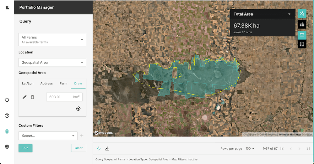
“The big problem we're trying to solve for our banking insurance customers is really understanding where rural, commercial and residential properties are in Australia. We've mapped every property in Australia, and then we built a capability for us to map our customers’ customers. We have a product called the Rural Intelligence Platform, which enables us to do that,” Willmott explained.
“We recently mapped a customer's 45,000 policies, which took us under two hours. Because we've geospatially located all their customers, we can now answer questions like: Where are they? Are they in a fire zone? Are they in a flood zone? Have they been impacted by a natural event? We can also answer basic questions like: How many assets are on the property?
“What we're really enabling is in real-time. You can understand which one of your customers is being impacted, not just at a postcode level, but at a property level, and that enables you to put forward your programs to support those customers."
The company has developed software to be as accurate as possible, enabling its clients to know not only which customers are impacted by natural catastrophes, but also how many buildings or structures are likely damaged.
To achieve this, DAS’ solution uses Geoscience Australia bushfire boundary data that typically updates every 15 minutes, along with state emergency services and government agencies data from the States.
One issue Willmott hopes the software will help address in Australia is underinsurance, which has been a longstanding challenge for both insurers and property owners, particularly in rural areas where structures may not always be accurately covered in policies.
“We know there is an under-insurance gap - not all the buildings on a property will be insured, which means for insurers, there's premium leakage on one end and claims leakage on the back end. But while mapping all the properties, then it becomes really straightforward to answer these questions: Has this property been impacted by fire?” he said.
“When there's a natural catastrophe, the number one question that the boards and regulators ask of the banks' insurers is how many of your customers were impacted? That normally takes days or weeks to answer that question. What we've done is build a capability to answer that question nearly instantaneously, so a customer can go in using the DAS platform and ask that question.”
The news comes as fires blaze across Victoria in the Grampians and Little Desert National Park. Just days ago, residents in the west Victorian areas of Brimpaen, Cherrypool, Glenisla, Glenisla Crossing, Grampians, Hynes, Mooralla, Nurrabiel, Rocklands, Telangatuk East and Zumsteins were urged to evacuate towards Horsham, where a relief centre has been set up.
Clients under DAS include banks, insurers, and firms who benefit from what Willmott describes as “agri-insights”, which include companies like Cargill Australia, who rely on data to understand what’s happening on each crop field.
“We always thought that understanding the impact of catastrophes was really critical to what we do. We think if we can help our customers understand the impact of natural events, they can respond more effectively and really improve the lives of their customers,” Willmott added.
“But we work with our customers. They tell us what events they're worried about and we then feed that into our development pipeline and build products around it. We're now looking to expand the same capability so we can monitor our cyclones and floods.”
When asked about the company’s future ambitions, Willmott noted he’s looking to take DAS to the USA to help local farmers and ranch owners.
“We'll be entering the USA in 2025 really focus on farm and ranch insurance. We've spent time in the last year really trying to understand if the problem we solved in Australia with under-insurance - did it exist in the US? And the answer was yes.
“We see Australia at a really interesting junction. We've made commitments to our climate risk modelling. A lot of customers have committed to understanding the natural capital of their customers, the climate impact of their customers and the carbon footprints of their customers.
“Our experience to date is unless they have mapped their customers, it's very difficult for them to deliver those commitments, and that's what we're most excited about - helping people do that.”
)